 Remarkable Road Trips
  The Rosie Project
  Things I Dont Want To Know
  The Year of Magical Thinking
  Remarkable Cricket Grounds
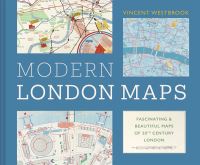
Modern London maps
£30.00
A fascinating miscellany of stunning twentieth century maps of London.
Out of stock
Featuring over 60 maps of London from the twentieth century, this fascinating miscellany provides an enthralling exploration of the history of the city.
One of the best ways to gain an insight into a city’s multilayered past is by deciphering its maps, and this curated collection of historical maps of London will help you do just that. Many of these hugely interesting and significant maps are also beautiful works of art and fascinating examples of design in and of themselves.
The majority of the maps in this collection have been drawn from the historical treasure house that is The London Archives, which has been housing London’s records since 1889. The maps are presented in thematic chapters, including:
Making Connections: Maps of the railways, tube system and roads.
Let’s Go Outside: London’s green spaces and the River Thames.
Picture This: Pictorial, decorative and artistic maps.
Perfect for map enthusiasts, history buffs and lovers of graphic design and London, this is a visually stunning book that you will spend hours poring over.
| Weight | 0.567 kg |
|---|---|
| Dimensions | 26 × 31.5 cm |
| Author | |
| Publisher | |
| Imprint | |
| Cover | Hardback |
| Pages | 176 |
| Language | English |
| Edition | |
| Dewey | 912.421 (edition:23) |
| Readership | General – Trade / Code: K |